
This stretch of water runs from the mouth of the Ill into the Rhine to Lake Constance. The current flood protection based on the state treaty between Switzerland and Austria is 3’100 m³/s.
In view of the high damage potential in the Rhine Valley and the danger to people if a dam breaks, the flow capacity is to be expanded to at least 4’300 m³/s and an emergency relief concept should be developed for an even higher flood.
At the same time, water ecology, river morphology and the opportunities for recreation and leisure use should also be improved.
On behalf of the International Rhine Regulation, we bring our expertise in the areas of river engineering, bed load transport and experimental engineering to the planning.
Significant contributions are made to:
- Detailing of targets such as freeboard of the dams and system security in the event of an overload
- Methodology for the selection of the best variant (rating system)
- Assessment of planning proposals and calculations by the planning team
- Recommendations for optimizing proposed solutions (especially with regard to flood protection, water morphology and sediment management)
- Support for public relations in the overall Rhesi project
You can find detailed information on the Rhesi project at https://rhesi.org (only in German)
In addition, we are involved in the implementation of several physical model tests. These are a large model test with a length of approximal 100 meters, which is set up in a hall in Dornbirn and is managed by the ETH Zurich, a model experiment regarding the development of economic methods for dam protection and bank protection at ETH Zurich as well as a Model test regarding scour protection on bridge piers, which is operated by the Vienna University of Technology together with us. Numerous hydraulic engineering and river morphological questions are to be answered with these model tests and the accompanying numerical modelling. These answers are required for the planning and the legal approval process, the construction and the subsequent maintenance of the water.

Bridge pier in a model test
In extensive model tests, scour protection measures were developed for selected bridge piers. The stability of the scour protection is decisively influenced by the accumulation of driftwood at the bridge pier. The protection measures are designed for the so-called highest expected flood (abbreviated as EHQ). The first video shows how the scour protection is rearranged during the passage of a flood wave, but overall protects the pier. The second video shows what happens if the scour protection is not sufficiently dimensioned. A large scour occurs directly at the pier, which in nature would cause the pier to collapse.
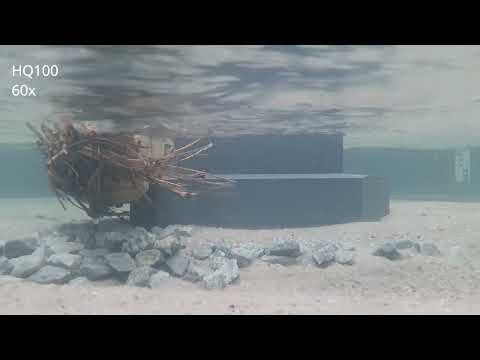
This video shows the development of scour around the pier during the discharge of a flood wave.
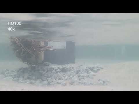
Video showing destruction of scour protection during the run-off of a flood wave.

Scour protection for a pier of the Oberriet-Montlingen bridge made of stones weighing between one and three tonnes.
Three models were examined in the test hall in Dornbirn. All models had a scale of 1 to 50, which means that all lengths in nature are reduced by a factor of 50. One centimetre in the model thus corresponds to 50 cm in nature.
The first model was of the situation before the planned project, in order to check whether the model correctly reproduces the processes in nature. In the second model, the Widnau/Hoechst area was modelled. Here, securing the bank in the area of the village of Au was a particular challenge, as the Rhine runs in a sharp right-hand bend here. The third and last model dealt with the planned large widening in the area of the villages Oberriet and Koblach. In this section of the river, the Frutz flows into the Rhine on the right side. In this model, so-called initial measures were developed, with the help of which the Rhine can develop to the planned project state with a width of up to 300 m as autonomously as possible.

Model test with replication of the situation prior to project implementation.
")
Model test with replication of the Rhine in the area of the villages of Au and Lustenau according to the planned project.

The Rhine in the planned project design at low water (view against the direction of flow).

The Rhine in the planned project design during a small flood (view in flow direction).
Video with the Rhine in a model test during a small flood, upstream of the mouth of the river Frutz.