This project was concerned with linking the areas of flood protection, river morphology and ecology in the implementation of river engineering measures. The aim of the project was to develop technically (hydraulic engineering and ecological) well-founded guidelines for the planning of current or future river engineering detail projects under the requirements of the EU Water Framework Directive.
CUSTOMER: Office of the Vorarlberg State Government, Department of Water Management.
Project team Contractor: REVITAL Civil Engineering GmbH, MAYR & SATTLER Engineering Office for Civil Engineering and Water Management, Federal Office for Water Management - Institute for Hydraulic Engineering and Calibration of Hydrometrical Current-Meters (IWB).
The main focus was on the evaluation and development of structural methods for bank protection. Due to our numerous uses in the vicinity of rivers, it is necessary to limit the free development of water bodies. In order to achieve the ecologically good condition of rivers as required by the EU Water Framework Directive and to secure or create new water habitats, appropriate construction methods are needed.
Depending on the availability of space, water body type-specific construction types were developed for selected sample stretches to protect the banks, which meet both ecological and flood protection management requirements. The sample sections are typical for two large rivers in Vorarlberg (Bregenzerach and Ill). Large amounts of bed load are also moved along these rivers during floods. The associated morphological dynamics of the watercourse must not lead to any endangerment of people or their material assets and was therefore an important aspect in this project.
The IWB played an advisory role in this project. The consultation covered the following main topics:
- impact of measures on water morphology and sediment transport (comprehensive survey of the watercourse)
- stability and thus load-bearing capacity of structure types in the event of flooding
- advantages and disadvantages of linking ecological and flood protective water management aspects in river engineering measures on rivers with high bed load
Results:
1. Design principles:
In order to achieve a planning result which, after its implementation, should have a long-term and sustainable effect, appropriate planning principles must be observed. Here, only those principles are dealt with which have a direct relation to hydraulic engineering, morphology and ecology. In concrete planning cases, these principles must be supplemented by space and problem-specific principles. The weighting of the individual principles will vary from case to case and must be determined before the start of planning.
- Planning is carried out integrative with a holistic approach (hydraulics, morphology and ecology) on the basis of an ecological mission statement, involving all affected bodies, stakeholders and the public.
- The core objective of planning is a dynamically stable river bed. Many further planning objectives can only be achieved with a river bed that changes dynamically within a known range. Examples of this are flood frequencies (flood protection but also ecology) and groundwater levels.
- Planning is put into an overall context with all areas upstream and downstream - catchment area-oriented planning.
- River morphologically robust solutions are to be chosen which react as little as possible to changes in boundary conditions (bed load balance, grain sizes, hydrology) with regard to the height of the river bed.
- Flood protection for settlement areas and important infrastructure.
- Improvement of the flood discharge conditions (no acceleration or increase of the flood peak due to the planned measures).
- Measures are based on the river morphology to be expected based on the given boundary conditions.
- Problem solutions can be predicted either on the basis of theoretical considerations, numerical calculations or physical models.
- Structural diversity of river bank and bed as well as their dynamics are generally preferred to fixations of bank and bed.
- The river continuum is ensured both in terms of ecology and sediment balance.
- If there is sufficient space available, areas adjacent to the watercourse are to be linked to the river and included in the dynamics.
- Wherever possible, the river's own potential for transformation is to be used for the implementation of measures (directing the river and observing the development calmly, instead of forcing the river in a short time and building non-sustainable structures).
- Larger measures are subdivided into partial steps and implemented over a period of several years on the basis of targeted observation (monitoring) depending on the actual watercourse development.
2. Data requirements:
The following data are required for the basic morphological assessment of a watercourse:
-
- Hydrology (characteristic discharges such as MQ, HQ1 to HQ100 or the highest design discharge, duration curves for mean, dry and wet discharge years or discharge hydrographs over a longer period of time representative of the river bed development)
- Watercourse geometry (bed widths, slope of river bank and bed - in each case bandwidths low, medium, high) for the actual state and for the planned state
- Flow resistance (for example, Manning Coefficient of the overall profile or of bank, bed and foreland including possible bandwidths)
- Bedload data (mean grain diameter dm calculated according to Meyer-Peter and Müller, 1948, further characteristic grain sizes of the bedrock material depending on the bedload transport formulae used, such as d30, d50, d90, as well as annual bedload loads, storage density and mass density of the solids - each with band width information)
- However, measured data on the start of bedload operation and transport rates for different discharges would be favorable but rarely available. This data would allow a calibration of the beginning of movement and of bedload transport formulas.
The quality of all results depends directly on the quality of the input data. This means that the better the data, the better and more reliable the result. To take into account the possible uncertainties in the data basis, bandwidths must always be examined.
If you would like more detailed information on the concrete application of the planning principles in connection with the data, please feel free to contact us.
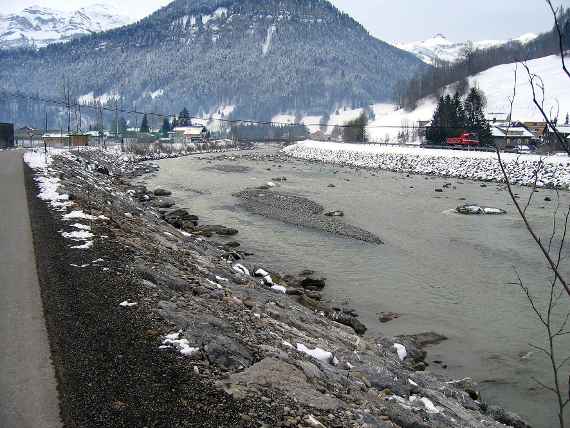
Bregenzerach in the Reuthe-Bezau section with river bank protection and individual ecological structural elements, view upstream
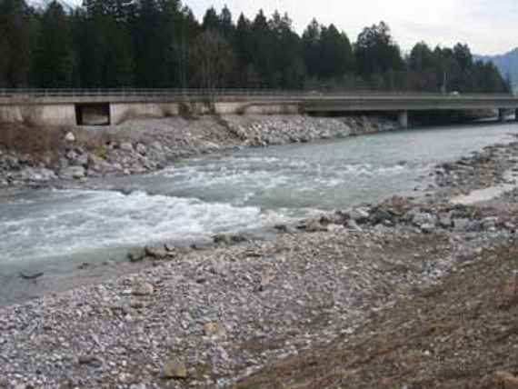
ILL in the Nenzing area downstream of the river Frutz, view against flow direction
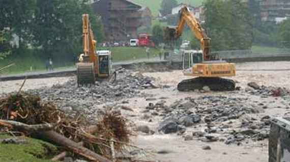
Bregenzerach in the village Au immediately after the flood in August 2005, view upstream. The Bregenzerach river has torn away the river bank protection and has found a new way.


