-BAW-Hasenhündl.jpg/jcr:content/Modellaufbau%20Titelbild%20(c)%20BAW-Hasenh%C3%BCndl.jpg "Man sieht in 3 Bildern die Entstehung eines wasserbaulichen Modells im Maßstab 1:40")
After constructing a new experimental flume for hydraulic model testing in winter 2024/2025, we completed the first model setup in spring 2025 to investigate the self-dynamic river widening of the Gail – all developed in-house.
The key steps – also shown in our time-lapse video – included:
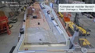
- Setting up profiles at 1-meter intervals, precisely aligned with natural survey data, filling the gaps, and creating a concrete surface for the fixed model sections (areas not subject to change – our boundary conditions)
- Filling the mobile model area with bricks to reduce the amount of special model sand needed and to allow for drainage and measurement equipment installation
- Conducting a leak test to check all installed components
- Spreading around 20 m³ of special model sand that accurately reflects natural conditions at scale, followed by rough pre-modeling
- Saturating the model to anticipate sand settlement and testing the entire setup
- Fine modeling of the mobile section and shaping the riverbanks – with colorful sponges simulating vegetation to best represent the current state
To build this model, several months of work were needed, moving tons of material – all with millimeter precision to replicate the geometry accurately. A big thank you to everyone involved for the fantastic setup!
We’re currently testing the measurement systems thoroughly. The current state will be calibrated using known flow rates to verify whether the model behaves similarly to the natural river. If successful, we can begin investigating the self-dynamic widening of the Gail.
Information about this project can be found in the current projects section: Self-dynamic river widening